
Taking the High Road: India’s Most Dangerous Highway
A public bus on India’s treacherous Manali-Leh Highway. (Photo: Angela de Klerk)
It’s
2:30 a.m. and the village is dead empty and absolutely still; creepy,
India is never this quiet. My sister, and I have been awake since
morning and fatigue is now sneaking up on us as we sit patiently on our
backpacks in a vacant parking lot. Finally, headlamps break the dark
night and our 4x4 minivan arrives. Deepak, our driver, look like he’s
been driving all night; I am praying he overdosed on his mother-in-law’s
potent chai.
I
say a silent, tearful goodbye to my backpack as Deepak ties it to the
roof. I take a seat — the only broken chair, go figure. For the next two
hours we are in and out of an uncomfortable sleep as the vehicle
gradually climbs up the bumpy mountain road, throwing us around like rag
dolls. I wake up to the sound of, well, nothing: we have stopped and
are in a major traffic jam at 6,561 feet above sea level in the middle
of the Himalaya Mountains.
As
I step outside to find a secluded spot (which is difficult, owing to
the lack of trees or any kind of bushes), I am hit in the face with
frosty air, chilling me to my bones. There’s heavy mist blocking the
view, but the intense emptiness and isolation that surrounds me is
awe-inspiring and I know we are in for one hell of a journey.

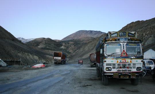
The quality of the roads throughout the entire journey. (Photo: Angela de Klerk)
The
300-mile Manali-Leh Highway is located in Northern India and connects
Manali, in the state of Himachal Pradesh, with Leh in Ladakh, in Jammu,
and Kashmir State. This route has only been open to foreigners for the
past 25 years. Before this, the popular route was to start in Srinagar
(in Kashmir) and make your way east to Leh. Due to the harsh weather
conditions the road is only officially open in summer, from about May to
September, depending on the amount of snowfall and how safe the roads
are. This is determined by the BRO (Border Roads Organization) of the
Indian Army.
After
some tea and biscuits, we are back in the car and on the move,
ascending steadily along with the other vehicles, all taking advantage
of the ‘good’ (meaning there’s a decrease in snowfall allowing for safer
roads) July weather.

The writer’s hard-core transport van. (Photo: Angela de Klerk)
We
pass cars stuck in icy mud sludge and people on motorbikes with faces
that seem frozen in time. I feel the penetrating iciness as we approach
the notorious Rohtang Pass, which lies at an altitude of 13,060 feet.
At
this moment, the fog clears and I experience a mind-blowing attack on
my senses. First of all, I recall a paragraph from my guidebook that
states: rohtang in the Bhoti language literally means “pile of
corpses,” owing to the weather- related deaths of people trying to cross
the pass. I try not to think of this as we travel scarily fast around
dangerous blind corners on a single lane gravel road with hanging
glaciers on one side, and a long descent (or fall) on the other.
Deepak’s
method of “safety” is hooting like crazy as we approach a corner and
then take the curve incredibly sharp and fast, sometimes even overtaking bends. I am a little scared, but I trust his instincts and it adds to the excitement of the journey.

Icy blue mountain lakes. (Photo: Angela de Klerk)
As
we progress, we glimpse turquoise rivers snaking through valleys and
terminating in tranquil icy blue lakes. The landscape turns from green
to brown to white. Soaring snow-capped peaks fill the sky and intimidate
us with potential avalanches. I almost feel the need to bow down before
Mother Nature and ask her for a safe passage. The road is rough and
bumpy; many portions are so damaged even a small amount of rain can
trigger a landslide.
I
have deep respect for cyclists who make the crazy decision to bike the
300 miles in this very high, harsh, and desolate environment, with its
heavy mist, fast-flowing streams, and extreme bitter cold. Military
vehicles pass by in large trucks, with a dozen eyes and the metal pointy
ends of guns peering out.

Pang, a high-altitude encampment. (Photo: Angela de Klerk)
We
stop a few times to get food. The high altitude is bearing on me and
I’ve developed a headache, nausea, and lightheadedness. We were supposed
to do the 300 miles in one go, but Deepak decides to stop for the night
in Pang, a tiny tent camp settlement that only exists in the summer
months to provide warmth and food for travelers. Pang is set at 14,763
feet, surrounded by looming mountains and complete bleakness, enveloped
in a clear, night sky bursting from top to bottom with stars.
I can’t imagine the amount of stamina the ladakhis
need to live in these merciless conditions, and I admire the
hospitality and kindness of this family whose language we don’t speak.
They make our stay in this remote place feel like home.
We huddle together in the makeshift tent; eating the most delicious vegetable thukpa (Tibetan noodles) and drinking hot masala chai.
A pile of cushions becomes our bed; it’s covered with heavy blankets to
keep out the bitter cold. We sleep soundly until morning.

Arriving at Taglang La, the second highest pass in the world. (Photo: Angela de Klerk)
We
get up early the next day. The sun is shining and the sky a brilliant
clear blue. We brave the cold — laughing at how our pee almost freezes
as it touches the ground — and take to the road again. We crawl up the
mountain behind slow trucks and soon we reach Taglang La, the second highest pass in the world, and stop for a break. Taglang La lies at 17,480 feet, and it’s quite an incredible feeling to be this high, especially since we didn’t have to hike it.

Prayer flags line to journey. (Photo: Angela de Klerk)
The air is thin, so I quickly eat chocolate and drink chai
to help with my altitude sickness, whilst admiring the bright colors of
the Tibetan prayer flags that are in deep contrast with the stark,
lunar semi-arid desert, which receives the prayers every time the flag
flutters in the wind.
From
here, it’s all downhill to Leh. After a few bouncy hours, we arrive in
the dusty ancient city. I am exhausted, but glad to be on solid ground
again.
Even
though we were stuck in a car for more than 20 hours, the landscape was
utterly flabbergasting and the glorious power of Mother Nature helped
us forget how uncomfortable our seats were. I recommend this trip to any
thrill-seeker who lives life literally on the edge, loves exchanging
stories whilst clutching a hot mug of chai, adores staring out
into a starry cold night, and who can place their life into the hands of
complete, yet remarkable, strangers.
No comments:
Post a Comment